Hiking on St. Croix
From cactus-lined East End trails to rainforest dams: the island's best hikes ranked by effort, with the safety notes that matter.
St. Croix has more walkable ground than any other U.S. Virgin Island and less trail infrastructure than you would guess from that fact. There is no park service trail network here the way there is on St. John; what the island offers instead is coastal headlands, old estate roads, a volunteer-built forest trail system, and some of the best guided cultural hikes in the Caribbean. This page is the index: every route worth walking, in one place, with the deep page linked wherever we keep one.
The hiking landscape
Set expectations first, because visitors who arrive with St. John in their heads are planning the wrong trip. Two-thirds of St. John sits inside a national park with a signed, mapped, maintained trail system. St. Croix's public land works differently. The island's federal park units are small and specific — a fort in town, a bay with a closed visitor center, an offshore islet — and none of them anchors a big trail network. Until very recently, walking here meant borrowed ground: jeep tracks, plantation-era roads, fishermen's paths, and routes kept open mostly by the feet of the people who love them.
That is changing, slowly and locally. The Virgin Islands Trail Alliance, a nonprofit trail-building group, cleared and opened the Windsor Farm trail network off Northside Road in 2022 and keeps adding projects. In August 2025 the territorial government purchased 2,386 north-west acres for a Maroon sanctuary park — now the USVI’s largest territorial park, with trail work under way by local volunteers. And the St. Croix Hiking Association has been running public group hikes for decades, publishing self-guided route notes and putting visitors on ground they would never find alone.
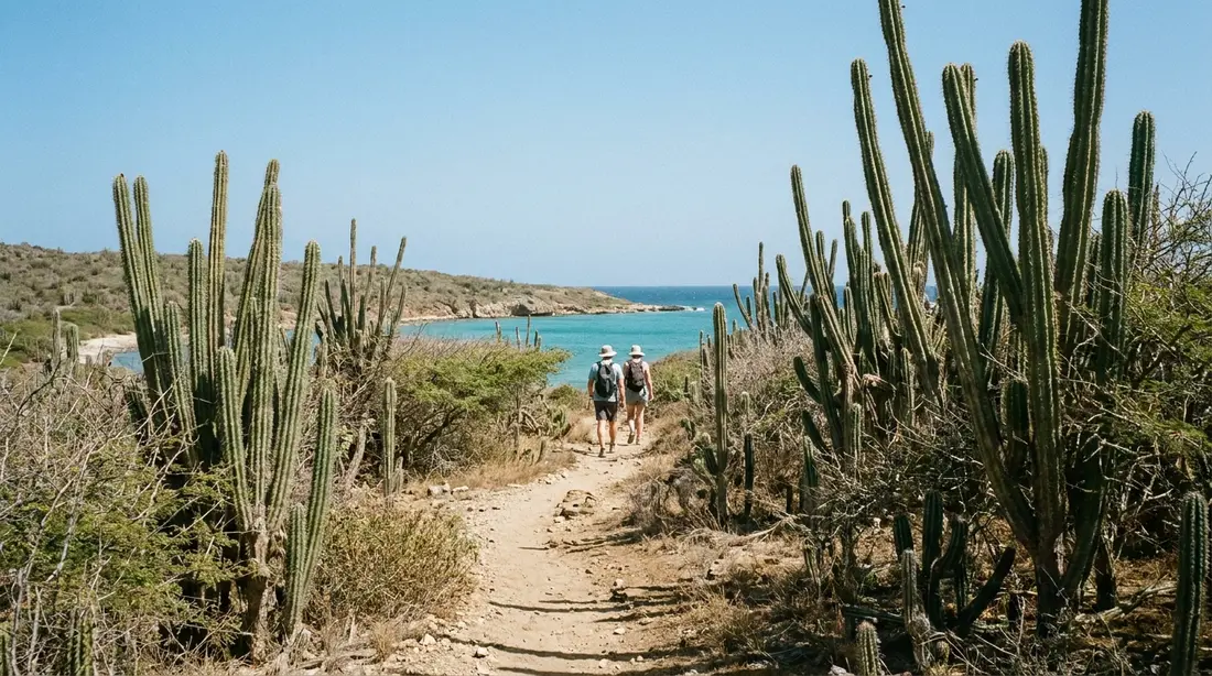
So the accurate picture is this: a handful of established, walk-it-yourself routes with real payoffs; a larger set of rougher routes that reward a guide; and a calendar of led hikes that opens the rest of the island. The geography sorts everything. The west is steep, forested and wet — over 50 inches of rain a year in the high country — so its walks are shaded climbs, muddy roads and cliff country. The east is low, dry cactus scrub, so its walks are open ridges and bare coastal trails where sun, water and an early start matter more than distance. The two-landscapes guide explains why one small island runs two climates; this page tells you what that means for your shoes.
How to use this index
Routes are grouped west, east, and mid-island, in that order, with the guided options after them. Each entry gives the shape of the walk — length, climb, shade, water — and links the full page where one exists, because several of these routes carry their own detailed guides on this site. All distances and times are approximate, drawn from published trail descriptions, hiking-club reports and our own notes; nobody surveys these routes officially, conditions shift with every wet season, and a figure that held in March can be wrong in October. Where a route needs a guide, we say so. Where it does not, we say that too.
The west end routes
Ham's Bluff Lighthouse
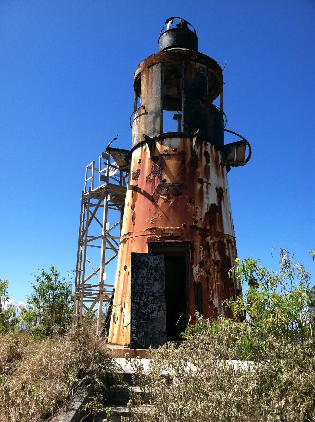
The gateway hike of the north-west: a climb of roughly eight-tenths of a mile each way, gaining something like 270 feet under forest shade, ending at the rusting 1915 Danish cast-iron lighthouse, an open bluff some 360 feet above the water. Half an hour up at a vacation pace, views down the whole north coast, and a trailhead with a documented break-in problem, so carry your valuables and leave the car empty. The Ham's Bluff guide has the turn-by-turn, the tower's history, and the reason you photograph it from outside.
Maroon Ridge
East of the lighthouse the cliff country runs high along the coast — the ground where escaped enslaved people built free settlements the Danish maps called Maroonberg, now the heart of the new territorial park. It is the island's most consequential walk and its least casual: unmarked, overgrown in stretches, with real cliffs, and best done the first time on a St. Croix Hiking Association outing. The full history and every route option are in the Maroon Ridge guide.
The tide pools at Annaly
The most famous hike on St. Croix: about 3.6 miles there and back from the Carambola resort trailhead, with roughly 550 feet of climbing, a rough rock finish, and natural pools you swim in only when the sea is calm and low. Sources disagree on the mileage and the sea makes the rules, so read the tide pools guide before you commit a morning to it.
Creque Dam Road and the forest roads
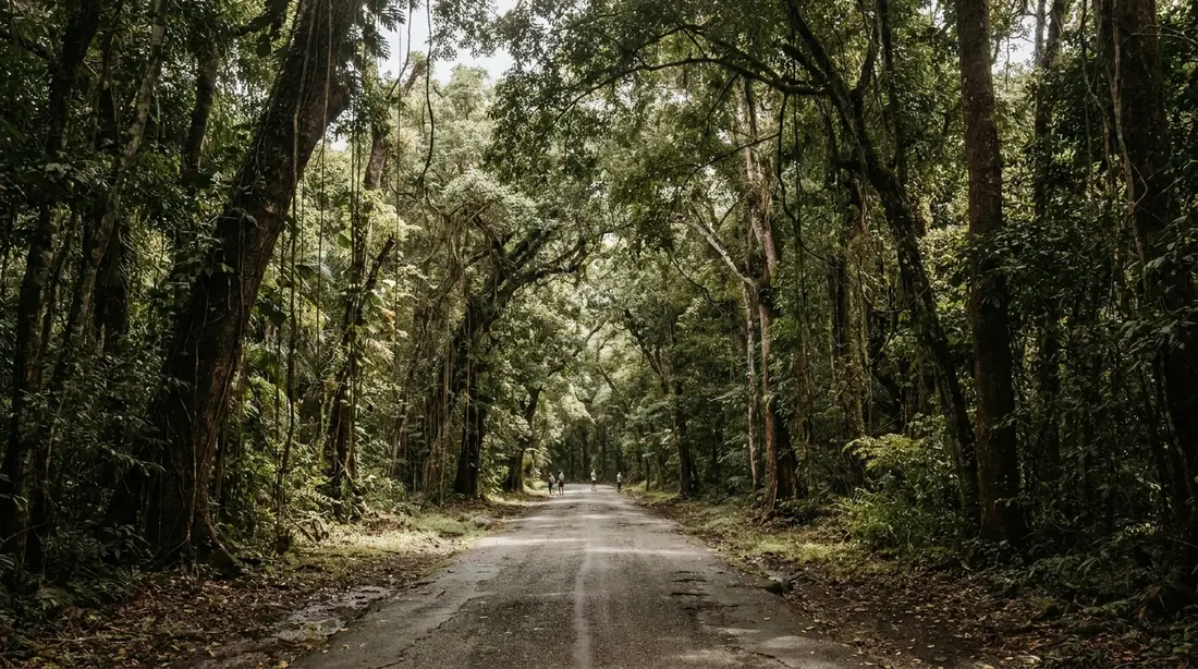
The wet north-west quarter is laced with old roads — some paved, most emphatically otherwise — and walking them is the easiest way into the island's rainforest. The classic short outing parks on Creque Dam Road off Route 63 and walks in to the stone dam finished in 1926 to water Frederiksted, now green with ferns and closed over by canopy. Longer road walks continue along the unpaved ridge routes toward Mount Eagle; locals treat those tracks as trails with route numbers, and on foot they cost you nothing that they cost a rental car. The Creque Dam guide covers the dam and the valley; the Scenic Road guide covers the ridge tracks and the Mount Eagle summit walk — about 25 minutes from the small parking area to the top of the island's 1,165-foot high point.
The Caledonia waterfall gut
St. Croix has one natural waterfall, in the Caledonia Valley of the north-west rainforest, and it runs on rain: strong in the days after a wet spell, down to still pools or a damp streambed in a drought. The route follows a gut, the steep ravine of a seasonal stream, and asks for wading and clambering over fallen trunks; these ravines can flood fast while rain falls upstream, so this is a guided-only walk timed to the weather: about an hour up, around two and a half hours round trip, rated moderate to difficult by the hiking association. Wet underfoot every time, and worth it when the water is moving.
Windsor Farm trails
The newest maintained walking on the island, and the gentlest forest option. The Virgin Islands Trail Alliance cleared, marked and opened this network of old farm and forest paths off Northside Road in 2022, with picnic tables and rest stops spaced out roughly every half mile. The main walking loop takes about an hour under tree cover, the grades suit any age, and mountain bikers share the wider stretches. Hikers' maps show loop options with up to 600 feet of climbing for those who want more. The hiking association schedules led walks here — a Windsor Forest history walk was on its 2026 calendar — and the shade makes it the west-side walk you can still do at ten in the morning.
Estate Mount Washington
A sugar-estate ruin you can actually walk, which is rarer than it sounds: most of the island's mill ruins stand on private land and are photographed from the road, as the mill ruins guide explains. Estate Mount Washington, in the forested hills near Frederiksted, is private too, but its owners keep the grounds open for respectful self-guided visits: about 13 acres holding the ruins of the sugar factory, the round "cockpit" where animals turned the cane mill, a bell tower, scattered coppers and equipment, and a walking labyrinth among the trees. Half an hour covers it at a stroll. Take nothing, pick nothing, and treat the open gate as the courtesy it is.
The East End routes
Goat Hill
The big walk of the dry side. Goat Hill tops out at 672 feet above the island's eastern tip, and the 360-degree summit view — Buck Island one way, Point Udall the other, both coasts at once — is the best on this half of St. Croix. The route is an old jeep track turned footpath: around two miles round trip from the trailhead across the road from Cramer's Park, beside the giant white radio-telescope dish that marks the start. Figure 1.5 to 2 hours. The catch is heat. There is no shade on any step of it, the ground is loose gravel and rolling stone, and the East End's dry air turns midday into a mistake; this is a first-light or last-light hike ten months of the year. Strong walkers can continue along the ridgeline west toward Sugarloaf Hill for a longer, harder day with more climbing. The Goat Hill guide has the fork-by-fork route.
Point Udall and the hike-in bays
The easternmost point of the United States is a drive-up, and the walk out to the Millennium Monument at dawn is covered in the Point Udall guide. The hiking starts where the pavement ends. From the small lot below the monument, a cactus-lined path drops through The Nature Conservancy's 301-acre preserve to Isaac's Bay, with Jack's Bay a rise beyond it — two beaches with no road, no facilities and, on most mornings, no people. There is also a longer way in that most visitors never hear about: the Jack Bay track leaves East End Road down by the radio telescope and reaches Jack's beach in about 1.2 miles, with short connector paths onward — roughly seven-tenths of a mile between the two bays, and a three-tenths spur to Hughes Point at the far corner. Walked as one circuit, the preserve's trail system runs about 3.6 miles and rates as a moderate outing on the hiking apps. Every step is open sun over dry scrub. Sturdy shoes, a real water supply and an early start are the whole game, and in nesting season the sand rules in the Jack's and Isaac's guide apply.
Long beach walks
The island's flattest hiking is on sand, and three shores earn the name. Ha'penny Beach on the south side is a long, wild stretch walked by locals, surfers and shore fishermen, with turtle nests in season and rarely another visitor. Grapetree Beach on the south-east runs narrow and empty behind its sea grapes for the better part of a mile. And Sandy Point National Wildlife Refuge holds the big one — two miles of bare white sand at the island's south-west corner — under the strictest access rules on St. Croix: open weekends only, 10 to 4, September through March, and closed completely from April 1 through August 31 for leatherback nesting. The Sandy Point guide carries the calendar; never drive out there without checking it.
Mid-island walks and Buck Island
Southgate Coastal Reserve
The easiest real nature walk on the island, and the best birding. The St. Croix Environmental Association manages this 100-acre reserve off East End Road — the grass parking area sits between Chenay Bay and the Cheeseburgers restaurant — protecting a coastal salt pond, mangroves, beach forest and upland grassland that together host more than a hundred bird species. Short flat trails with benches and educational signs thread the property; the walk from the left-hand trailhead back to the salt pond runs about three-tenths of a mile, and a bird-viewing hide overlooks the water. Sea turtles nest on the beach berm, so stay on the paths. No fee, no gate, no facilities: bring water, repellent and binoculars, and go early, when the pond is busy.
Salt River Bay
Hedge this one. Salt River Bay National Historical Park protects 1,015 acres of mangrove estuary and the 1493 Columbus landing site, but its visitor center has been closed indefinitely since Hurricane Maria, and the park maintains nothing you could call a signed trail system. What you get on foot is still worthwhile: the short walk around the overlook where the whole bay reads at a glance, the shoreline at Columbus Landing Beach, and informal paths near the mangrove edges — uneven ground, slick after rain. The estuary itself is best traveled by kayak, day or night. History and logistics are in the Salt River guide.
Garden and estate strolls
Three more places file under walking rather than hiking, and each earns an hour. The St. George Village Botanical Garden grows over a thousand tropical species through the stone ruins of an old plantation village — the rare garden where the architecture pulls equal weight — and its paths are covered in the garden guide. The Estate Whim Museum's 12 acres of grounds, windmill and factory ruins walk you through the sugar economy on its limited open days; the interior of the great house has stayed shut since the 2017 hurricanes, as the Whim guide notes. And Estate Little Princess, The Nature Conservancy's preserve near Salt River, mixes short ruin-and-shoreline trails with a working coral restoration campus — visits run on a scheduled-tour basis, so confirm arrangements with the Conservancy before building a morning around it.
The trail you take a boat to
Buck Island Reef National Monument keeps a marked land trail over its 176-acre island: up from the beach through dry forest to an observation point around 300 feet up, with the elkhorn reef and lagoon laid out below, then down the far side. Most visitors cross it in well under an hour between swims. Two cautions travel with it — the climb is hot and shadeless in the middle of the day, and the National Park Service marks poisonous manchineel trees along the route that you neither touch nor shelter under. Getting there takes one of the five permitted boats; the Buck Island guide covers all of it.
Guided hiking
On St. Croix the guided hike is the unlock, and treating it as the tourist-grade option gets the island backwards. The routes with the deepest payoffs — the Maroon country, the Caledonia gut, the far ridge roads — are exactly the ones without signs, and the people who lead walks here have been keeping these paths open for decades.
- St. Croix Hiking Association — the island's hiking institution: a nonprofit that runs group hikes and outings roughly monthly, open to anyone, with a published calendar, self-guided route write-ups on its site, and led trips that have covered Windsor Forest, Mount Eagle, the Maroon heights, Caledonia and more. Membership dues at last check ran $30 for an individual, $50 for a couple, $60 for a family and $10 for students, with discounted hike admission as the main perk; non-members simply pay a little more per hike. If your dates line up with a calendar event, take it — this is the cheapest expert guiding in the Caribbean.
- CHANT — Frederiksted’s heritage-and-nature nonprofit on Custom House Street, running eco hikes into the rainforest alongside its historical walking tours of Frederiksted and Christiansted and an Alexander Hamilton route. The culture-first framing changes what you see on the same ground.
- BushTribe Eco Adventures — the standing commercial option for the tide pools and other north-west walks, with small-group guided hikes around $50 per person at last check, plus custom trips.
- VI Eco Tours — runs a rainforest discovery hike to Creque Dam and coastal viewpoints, with the botany explained as you walk.
- Ridge to Reef Farm — the organic farm in the Creque Dam valley hosts tours, dinners and farm stays by arrangement; a farm visit pairs naturally with a forest road walk.
- Tan Tan Tours — strictly speaking a 4WD outfit, but its jeep runs to the Annaly coast are how non-hikers reach the tide pools, and the last stretch is still on foot.
The guided-versus-solo call, route by route, is simpler than it looks. Solo is fine on the established, well-trodden walks: Ham's Bluff, Goat Hill, the Jack and Isaac trails, Windsor Farm, Southgate, and the garden and estate strolls. Take a guide, at least the first time, for the tide pools, anything on Maroon Ridge past the lighthouse, the Caledonia gut always, and the long unpaved ridge roads if route-finding is new to you. Small-island operators shift prices and schedules without warning; reconfirm every detail at booking time.
Heat, water and sun
The distances on this page are small, and that is the trap. Tropical walking runs on a different arithmetic: at 17 degrees north the sun works you from mid-morning onward, the humidity taxes every climb, and a two-mile figure that means forty easy minutes at home means a soaked shirt and a drained bottle here. The discipline that keeps St. Croix hikes pleasant fits in five lines. Start at first light — every regular hiker on this island does, and the association's group hikes meet at dawn for a reason. Carry more water than the mileage suggests: a liter per person on the short walks, double that on anything over an hour, because no trail on this island has a tap, a vendor or a refill anywhere on it. Cover up rather than trusting sunscreen alone — a brimmed hat and a sun shirt outwork reapplication, and what sunscreen you do use must be mineral, since the territory bans the common chemical formulas. Set a turnaround time and obey it; there is no lighting on any route and dusk drops fast. And tell someone at the villa where you went, because phone coverage dies in the folds of the ridges and behind the East End hills. The safety guide carries the island-wide version of these rules; on the trail they stop being general advice and become the whole difference between a good morning and a rescue.
Footwear
Nobody needs boots on St. Croix, but flip-flops fail on every route above, and the right shoe changes by terrain. For the forest walks — Ham's Bluff, Creque Dam, Windsor Farm — wear closed trainers with real tread: the ground is roots, clay and wet leaves, slick for days after rain. For the rock-finish routes — the tide pools above all — you want grip that survives wet stone, either amphibious shoes or trainers plus water shoes to change into, with soles thick enough for urchin country. For the dry East End — Goat Hill, the bay trails — closed toes matter more than tread: the hazard is loose gravel, cactus spines and hot stone, and open sandals lose that argument in the first quarter mile. The beach walks forgive anything, and the gardens and estate grounds ask only for shoes you can stand in for an hour. If you pack one pair for the whole trip, make it lugged trail runners and add cheap water shoes on island.
Wildlife and plants on the trail
The trails carry more animal traffic than the roads. White-tailed deer — on the island since Danish times — browse the scrub edges and cross the East End tracks at dawn and dusk, exactly the hours hikers keep. Hermit crabs commute in astonishing numbers, whole processions of borrowed shells working uphill through the beach forest and across the paths; watch your feet in the leaf litter. Mongoose flash across the forest roads, anoles do push-ups on every warm rock, and the full cast is in the wildlife guide.
Two residents deserve specific respect. Jack Spaniards — the red-and-yellow paper wasps of the Virgin Islands — hang their nests along trail edges and low brush, and the first sign of one is usually the sting, sharp and electric, with swelling that can run a day or two; unlike bees they sting repeatedly. They are calm unless the nest is disturbed, so the protocol is simple: move slowly, never swat, and if one lands on you, blow it off gently and keep walking. The manchineel tree is the botanical hazard: every part of it is toxic, sap included, and rain dripping through its canopy burns skin, which is why sheltering under a beach tree with small green apples is the one thing you never do here. Marked specimens stand along the Buck Island trail; unmarked ones grow on wild shores, so learn the leaf. Neither hazard is common enough to change a plan — both are common enough to know on sight.
When to hike
Hour first, month second. On this island the time of day outweighs the time of year: dawn starts make every route on this page better, and midday ruins the exposed ones in any season. That said, the calendar helps. December through April is the sweet stretch — the driest footing on the western trails, and the Christmas Winds keeping the eastern ridges cool through mid-March. High summer moves everything to the first and last hours of light, especially Goat Hill and the bay trails, where the dry heat is the actual difficulty. September through November is the wet heart of the year: the west turns green and muddy, the guts run, and the forest is at its best and its slickest.
Rain splits the island's trails into opposites. After a wet spell, stay off the western forest routes for a day or two — clay footing, swollen guts, and the ravines flash while rain is still falling upstream — but that same rain is precisely what switches on the Caledonia waterfall, so the guided gut walk is a days-after-rain outing by design. The East End barely notices: its trails drain fast, shed mud within hours, and give you somewhere excellent to walk while the west drips dry. When showers sit over the rainforest, drive east; the reverse trade works too.
Routes at a glance
Figures are approximate, compiled from published descriptions and recent hike reports; verify conditions locally, and treat every time as a heat-adjusted vacation pace.
| Route | Round trip | Difficulty | Shade / water to carry |
|---|---|---|---|
| Ham's Bluff Lighthouse | ~1.6 mi, ~270 ft up | Moderate: steep, short | Shaded climb, open top / 1L |
| Maroon Ridge (past the lighthouse) | Varies; add 1–3+ mi | Hard: unmarked, cliffs | Little shade / 2L+, guide advised |
| Annaly / tide pools from Carambola | ~3.6 mi, ~550 ft of climbing | Moderately strenuous, rock finish | Mixed shade / 2L |
| Creque Dam road walk | 1–3 mi as chosen | Easy–moderate | Deep shade / 1L |
| Caledonia waterfall gut | ~2.5 hours | Moderate–difficult, wading | Shaded, wet / guided only |
| Windsor Farm loop | ~1 hour | Easy | Good shade, rest stops / 1L |
| Mount Eagle from the parking area | ~50 min | Easy–moderate | Part shade / 1L |
| Goat Hill | ~2 mi, to 672 ft | Steep, loose rock | No shade anywhere / 2L |
| Jack's and Isaac's Bays circuit | Up to ~3.6 mi | Moderate, fully open | No shade / 2L |
| Southgate Coastal Reserve | ~1 mi of flat trails | Easy | Partial shade / 1L |
| Buck Island land trail | Under 2 mi, ~300 ft up | Moderate, hot | No shade on the climb / boat access |
Questions guests ask
Is there an official trail map of St. Croix?
No single one exists, which surprises people used to national-park islands. The practical substitute is a stack: the hiking apps cover the established routes (the bay trails, Goat Hill, Ham's Bluff, the Carambola trail), the St. Croix Hiking Association publishes self-guided write-ups for several more, and the Virgin Islands Trail Alliance posts its projects. For everything beyond those, local knowledge is the map — which is one more argument for taking at least one association or CHANT outing early in the week and asking questions the whole way.
Which hike should I do if I only do one?
Match it to your group rather than a ranking. For views per step, Goat Hill at first light is unbeaten. For a swim as the payoff, the tide pools — on a calm-sea day only. For shade, ease and history in one hour, Windsor Farm or the Ham's Bluff climb. For weight, the Maroon Ridge outing with the hiking association is the walk people are still talking about a year later. If the week allows two, pair one west and one east; they are different islands underfoot.
Are the trails safe to walk alone?
The established routes are commonly walked solo and the island's standing cautions are ordinary ones: carry water, start early, leave nothing visible in a trailhead car, and tell someone your plan, because phone signal drops behind the ridges. We would not go alone into the unmarked country — the ridge past the lighthouse, the far forest roads, any gut — where a turned ankle without coverage becomes a long afternoon. Groups of two or three solve most of it, and the association's calendar solves the rest.
Can kids handle these hikes?
Several, happily. Southgate's flat mile, Windsor Farm's shaded loop, the Ham's Bluff climb for kids who manage half an hour uphill, the walk down to Isaac's Bay for sturdy school-age walkers with water of their own, and the Buck Island trail as part of a boat day. Goat Hill works for older kids at dawn; the heat, more than the grade, is the limiter. The tide pools hike and anything guided-only sit at the judgment end — the tide pools guide covers the kid question in detail.
Do any hikes require permits or fees?
No permits, and almost no fees. The preserves and reserves in this index are free to enter; the hiking association charges a small per-hike admission, typically around ten dollars for non-members at last check; commercial guides set their own prices; and Buck Island's cost is the boat, since only permitted operators land there. The two access rules that actually bite are calendars — Sandy Point's weekend-winter-only schedule with its full spring-and-summer closure, and Estate Little Princess's scheduled-visit model.
What should be in the daypack?
Water beyond what seems reasonable, a brimmed hat, a sun shirt, mineral sunscreen, bug repellent for the forest routes, real shoes for the terrain (see the footwear section), a dry bag for the phone on any rock-and-water finish, and cash for the guided outings. Add binoculars for Southgate and nothing valuable left in the car anywhere. Our packing guide covers the trip-level version; the daypack version is mostly water and sun cover, repeated until it sounds boring.
Is there anywhere to hike on a rainy week?
Yes — and one walk that only exists because of rain. The East End trails drain fast and are usually walkable within hours of a shower. Windsor Farm's canopy shrugs off light rain. And a wet stretch is exactly when the Caledonia waterfall runs, so the guided gut walk in the days after a system passes is the best version of that outing. What rain closes is the western clay and the ravines while water is still moving; give those a day or two.
A villa base for hiking days
No trailhead in this index sits much more than an hour from any house on the island, so base wherever the rest of your week lives and treat the far end as the early-start outing. From our East End and Christiansted homes, Goat Hill, the bay trails and Southgate are minutes away — guests at The Cerulean can be on the Isaac's Bay trail before the sun clears the ridge — while the western forest is an easy dawn drive. Sunset Sea-Clusion in Frederiksted flips the map: lighthouse, dam and rainforest close, the East End for a sunrise mission. Browse the full collection, and tell us which walks are on your list; we will point you to the right calendar and the right morning.
Sources
Written from official and first-party sources, checked August 2026. Hours, prices and event dates change — confirm before you go.
In this guide
Stay nearby
On The Shoys beach: six bedrooms, six baths, pool and hot tub, room for twelve, and the beach through the back garden.
 Shoy's Beach House6 bd · 6 ba · sleeps 12 · Christiansted
More in Land & Adventure
Sources
12 references, listed in full at the end of this guide — official park, refuge, tourism-board and business sources, checked August 2026.