Driving Mahogany Road
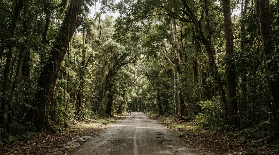
Route 76 tunnels through the rainforest between Frederiksted and the north shore, past the Domino Club and some of the island's biggest trees.
Mahogany Road is Route 76, the paved forest road across St. Croix's wet western hills, and the prettiest stretch of asphalt on the island. It climbs from the coast road above Frederiksted, runs beneath a closed roof of mahogany, kapok and turpentine trees, passes a woodworking shop and a bar with beer-drinking pigs, and comes down near Grove Place in the center of the island. This page is the full reference for the road itself: where it runs, what it is like to drive, the history of the trees over your head, every stop worth knowing, the side roads, and the practical details nobody prints on the rental-car map.
Where the road runs
Route 76 has two ends. The western end meets Route 63, the west coast road, a short distance north of Frederiksted; the turn is easy to miss at speed, so watch for it once the town thins out. From there the road climbs east into the hills, winding through the forested valleys of the island's northwest quarter. The eastern end comes out at Grove Place, a historic settlement in the middle of the island a few minutes from Centerline Road (Route 70) and the Kingshill area. In other words, the road links the island's flat central spine to its west coast by going over and through the forest instead of around it.
Distance and time both need hedging, because the numbers feel wrong in both directions. Call the road roughly five to six miles end to end, and treat that as approximate; odometers and mapping apps disagree slightly on pavement this bent. Budget 20 to 30 minutes for the crossing with no stops, which sounds slow for the mileage until you have driven it. With a Domino Club lunch and a browse at the wood shop, the same five miles fill half a day happily.
Either direction works. Driving west to east, the forest opens suddenly onto the farm country of the central plain, which is a fine reveal. Driving east to west, the road delivers you to the coast with the afternoon sun ahead of you and Frederiksted's beaches minutes away, which is why most visitors run it that way late in the day. If you are building a bigger loop, the road is one leg of the classic circuit in the drive-around-the-island guide; this page goes deeper on the leg itself.
What the pavement is like
The road is paved the whole way, which surprises people who have read about St. Croix's rough forest tracks. The rough tracks exist, and they are covered below, but Route 76 is not one of them. What it is: narrow, bendy, patched, and dark. In places the usable width is closer to a lane and a half than two lanes, with vegetation pressing in from both shoulders. The surface carries patches over patches, the occasional pothole after a wet season, and leaf litter that stays damp in the shade. None of it needs four-wheel drive. An ordinary sedan crosses comfortably at sensible speeds, and the drivers who complain about the road are generally the ones who tried to take it at 35.
The defining feature is the canopy. For long stretches the trees meet overhead and the road runs through solid shade; photographers should know the light under there drops several stops, so eyes and cameras both need a beat to adjust when you enter from bright sun. The shade also means the road dries slowly. After rain, expect a wet surface long after the coast has baked dry, and brake earlier than the pavement seems to ask. Which, to be clear, is part of the appeal — the forest after a shower steams and glows, and the wettest corner of the island wears rain better than anywhere else on it; the rainy-weather journal makes the case for driving this road on exactly the day the beach plan falls apart.
Sharing a narrow forest road
Route 76 is a working road, and that changes how you should drive it. Residents live along it and off it, commute on it, and know every bend by muscle memory, so a local pickup will close the gap behind you faster than seems possible. The etiquette is simple: at the next straight stretch or wide spot, signal, ease left onto the shoulder, and let them by. You will get a wave, and you will enjoy the road more without a bumper in your mirror.
Remember also that St. Croix drives on the left, and a narrow shaded road full of curves is exactly where a mainland driver's instincts try to reassert themselves. Keep left through every bend, take blind corners at a speed you could stop from, and use the horn lightly on the tightest hairpins if sightlines are nil. Oncoming traffic on the narrowest pinches sorts itself the way it does on single-track roads everywhere: whoever is nearest a wide spot yields. Full island driving rules, including the left-side adjustment and the animal hazards, are in the driving guide.
Photo stops need their own discipline. The road's most photogenic moments arrive mid-bend, where stopping would be dangerous. Wait for a pull-off or a straight with visible shoulder before parking, get fully off the pavement, and never leave the car on a blind curve, however brief the errand feels. There is always another gorgeous stretch a quarter mile on.
How the mahogany got here
The question every passenger eventually asks is whether the giant trees are native, and the answer is a good story. Mahogany is Caribbean, broadly speaking — West Indian mahogany, Swietenia mahagoni, grows wild on Cuba, Hispaniola, Jamaica and the Bahamas — but on St. Croix the trees arrived by decision, and island historians can name the year. In 1775 the Danish colonial government had mahogany planted along the west-end road that now carries the name, which means the oldest trees shading Route 76 have stood through two and a half centuries of hurricanes, droughts, and changes of flag. V.I. ecologist Olasee Davis, who has written extensively on the island's trees, treats the roadside mahoganies as cultural landmarks as much as botany.
Two of the world's five mahogany species grow on St. Croix, and both were brought: Swietenia mahagoni, the West Indian, and Swietenia macrophylla, the bigger-leafed Honduran species. The planting continued long after the Danes started it. In 1908 the colonial government established a mahogany plantation at Davis Bay on the north shore, and in the 1930s Civilian Conservation Corps crews planted mahogany along Queen Mary Highway, which is why Centerline Road has its own processions of big trees. The wood itself explains the effort: dense, reddish, and prized for furniture and boatbuilding, mahogany from the Danish West Indies became famous in the form of the four-poster beds and cabinetry that filled plantation great houses. Estate furniture made from island wood still turns up in the island's museums.
The rest of the canopy
Mahogany takes the naming rights, but the roof over Route 76 is a mixed one. Kapok — the silk-cotton tree, with its buttressed trunk and spirit lore — is the giant of the forest. The turpentine tree announces itself with peeling coppery bark, and samaan spreads wide crowns over the clearings, with ferns and vines filling every layer below. The botany of this forest, including why the local name Rain Forest outruns the technical definition and what all these species are doing on a semi-arid island, is told properly in the two-landscapes guide; the short version for the driver's seat is that you are crossing the wettest of St. Croix's climate zones, a band of hills collecting upward of 50 inches of rain annually while the East End makes do with half that. The whole western circuit built around this forest — the roads, the dam, the coast below — is assembled in the rainforest and west end guide.
Storms and the salvage tradition
The canopy you drive under is a survivor, and its scars are part of the reference. Hurricane Hugo crossed St. Croix directly in September 1989 and flattened much of what stood; Hurricane Maria passed just south of the island on September 20, 2017, and its winds stripped and toppled trees across the forest even without a direct hit. Tropical canopies rebuild fast — leaves first, structure over years — and drivers today see a closed roof again along most of the road, though a careful eye picks out the broken crowns and the younger growth threaded through the old giants.
The storms feed a tradition worth knowing before you reach the wood shop below: on St. Croix, working mahogany is largely a salvage craft. Nobody is felling the roadside giants for bowls. The island's woodworkers have long taken their raw material as windfall — trees and limbs the hurricanes bring down — a practice locals date back to the harvest of downed wood after Hugo. When you buy a mahogany board on this road, the storm cut the tree.
St. Croix LEAP
About two miles up from the western end stands St. Croix LEAP — the Life and Environmental Arts Project — an open-air woodworking shop under a tall roof in the trees. Founded in the 1970s as a cooperative dedicated to hand work, conservation and self-development, LEAP spent decades as the road's essential stop: sawyers and carvers turning storm-salvaged mahogany and other local hardwoods into serving boards, bowls, mirrors, clocks and one-off tables, with the sawdust still on them.
Report its current state with care, because recent visitors describe a quieter place than the guidebooks do. The big shelter, the stacked slabs and the finished pieces are still there, and travelers in the last few years have found a lone elder woodworker presiding and work for sale; others have found nobody about. Treat LEAP as a slow-down-and-look stop rather than a scheduled one: if the shop is open and someone is working, stopping is worth it, both for the craft and for the shelves of finished pieces at prices tied to the wood rather than to a marketing plan. If it is shuttered when you pass, the state of the place tells its own story about how hard it is to keep a forest cooperative running for fifty years. There are no posted hours to rely on; at last check no functioning website existed either.
Mt. Pellier Domino Club
The road's famous stop sits at 49 Mahogany Road: the Mt. Pellier Domino Club, a roofed, wall-less bar in the forest that has held a license since 1971 and grew out of a pig farm that had been pouring drinks informally for years before that. Two things made it an institution. The first is MamaWanna, the house rum infusion of honey, roots, herbs and spices in the old Caribbean bush-rum line, poured by the shot and sold by the bottle. The second is the pigs.
The pigs are real, large, and enthusiastic, and the beer they drink is non-alcoholic — a detail the club is careful about and visitors should be too. You buy a can at the bar for a few dollars, hold it out, and the pig opens and empties it with a speed that has been delighting road-trippers for decades. At last check, pig visiting ran through daytime hours, roughly mid-morning to late afternoon, with a small admission of a dollar or two; the club itself operated Tuesday through Sunday from morning onward with no posted closing time, closed Mondays. None of those details is firm — the place runs on its own clock — so check the day of and keep your plan loose. Bring cash — there is no ATM in the rainforest — and if there is Caribbean food that day, order early, because the kitchen stops when the pots empty. The deep version, with the family history from founder Norma George to the current keepers, is in the Domino Club guide, and the club also appears in our journal round-up of the island's overlooked places.
One sober line, since the club sits mid-road: whoever is driving stays on water or takes exactly none of the MamaWanna. The bends do not grade on a curve.
The Grove Place end
Come down the eastern side and the forest lets go all at once, dropping you into Grove Place, one of the island's oldest villages and a center of Crucian labor history. The settlement's landmark is a baobab tree estimated at more than 250 years old, an African species whose seeds crossed the Atlantic with enslaved people and whose shade later hosted the meetings that built the Caribbean's first organized labor movement; the story is told with the rest of the mid-island's history in the two-landscapes guide. From Grove Place you are a few minutes from Centerline Road, which puts the Cruzan distillery, Estate Whim and the botanical garden all within easy reach — the natural second half of a west-island day.
Creque Dam Road and the Scenic Road
Two unpaved connections tie Mahogany Road into the wider forest network, and both deserve clear labeling because they are a different class of driving.
Creque Dam Road, Route 58, runs through the heart of the forest between the Route 63 coast road and the high country, passing the stone Creque Dam of 1926, built to store up to nine million gallons of water for Frederiksted and now standing mossy and quiet in the trees. Sections are rough, and conditions swing with the rain. The dam, the walking around it, and the island's one seasonal waterfall in the Caledonia Valley are all covered in the Creque Dam guide. Along this road also sits Ridge to Reef Farm at Estate Little La Grange, the island's only certified-organic farm, founded in 2010; it sells produce, sauces and jams from its farm stand — at last check Wednesdays and Saturdays, 11 a.m. to 3 p.m. — and hosts tours and farm stays by arrangement rather than walk-in. If the stand is open when you pass, it is the best grocery stop in any forest anywhere.
The Scenic Road, Route 78, is the old ridge route across the island's western spine, and it is 4WD territory, full stop: unpaved, rutted, washout-prone after rain, and unpublished in its current conditions at any given moment. In dry weather with a proper high-clearance vehicle it rewards the effort with ridge views over both coasts; in wet weather it can strand a rental. Some rental agreements exclude unpaved roads entirely, so check yours before turning off the pavement. The judgment call, the vehicle question, and the route options are laid out in the Scenic Road guide. The clean way to think about the trio: Mahogany Road is the forest for everyone, Creque Dam Road is the forest for the willing, and the Scenic Road is the forest for the equipped.
Walking from the road
Route 76 doubles as an access corridor for foot travel. Informal footpaths leave both sides of the pavement into dry streambeds and shaded glens, and the old-road network means a walker can connect from Creque Dam Road through the forest to come out on Mahogany Road near LEAP. Two cautions frame all of it. First, these are unmarked, unmaintained paths on an island without a formal trail system, so treat any walk here as exploratory: long pants, real shoes, water, bug spray, and a turnaround time. Second, the streambeds — guts, in island usage — flash-flood when rain falls in the hills above, so stay out of them entirely when heavy rain is falling or forecast. Guided options solve both problems at once; the operators who run rainforest hikes, and the island's wider trail lineup from easy to committing, are in the hiking guide.
Timing the light
The road changes character by the hour, and choosing your slot is free. Early and late, the low sun slips under the canopy edge and side-lights the trunks, which is when the forest photographs best. Midday sends light straight down through gaps in the roof, spotlighting patches of road in a way that reads dramatic in person and contrasty on camera. The hour after rain may be the road at its finest — steam off the pavement, saturated bark, drips flashing in the gaps — and it costs only wet shoulders at the photo stops.
Late afternoon needs one warning attached: under that roof, dusk arrives early. The road goes dark well before sunset reaches the coast, there are no streetlights, and headlights-on is the rule from the moment the shade thickens. Plan forest crossings for full daylight and save the last light for the west coast, where it belongs. On the descents in either direction, use low gear and let the engine hold you back rather than riding the brakes through a mile of bends — rental brakes fade, and the bottom hairpins are where you want them fresh.
Animals on and over the road
Drive attentively and the forest supplies a small safari. Mongooses cross the pavement in quick gray dashes at all hours, most boldly at midday. White-tailed deer, on the island since Danish times, step out at dawn and dusk along the forest edges, and hitting one ruins everybody's week, which is one more argument against speed. Chickens and roosters govern the Domino Club's parking area with total confidence. Overhead and in the understory, the wet side concentrates the island's birdlife: bananaquits working every flowering tree, both of the island's hummingbirds in the blossoms, pearly-eyed thrashers raiding fruit, and big scaly-naped pigeons moving through the canopy. Hermit crabs cross the road after rain, which is a hazard only to the crabs, but swerving for wildlife on a narrow bend is how fender meets tree — slow down instead. The island's full cast, introduced villains included, is in the two-landscapes guide's wildlife section.
Coming out at the coast
Westbound, the road's last act is the drop to Route 63, and the payoff is immediate: you leave the deepest shade on the island and meet its calmest, sunset-facing water within minutes. Turn south and Frederiksted opens up — the fort, the pier, the waterfront restaurants — all covered in the Frederiksted guide. Turn north and Rainbow Beach is a few minutes up the coast with its beach bar and water-sports shack; the Rainbow Beach guide has the details, and the wider lineup is in beaches near Frederiksted. The forest-then-swim sequence is the whole logic of a west-island day: canopy in the morning or midday, Domino Club lunch, salt water by mid-afternoon, sunset from the sand. Northbound travelers can instead work up Route 63 toward Ham's Bluff and, with more driving, around to Cane Bay for the swim — the current body of a classic rainforest morning.
Fuel, signal, and other practicals
- Fuel: there are no gas stations on Mahogany Road or anywhere in the forest. Fill up in Frederiksted or along Centerline before you climb. The crossing is short, but idling at pig-feeding time burns more than you think.
- Food and water: the Domino Club is the road's only kitchen, on its own schedule. Carry water regardless.
- Phone signal: coverage in the forest valleys is patchy for some carriers. Download offline maps before you enter, and do not count on a bar of service at the bottom of a gut.
- Restrooms: the Domino Club when open; otherwise Frederiksted before you start.
- Motion sickness: passengers prone to it should sit front and look far ahead; the bends are constant for 20 minutes.
- Larger vehicles: the road is crossable in anything a rental agency will give you, but the wider the vehicle, the more of the lane-and-a-half pinches become negotiations. Vans manage; drivers of them earn their lunch.
- After dark: legal, paved, and not recommended. No lights, no shoulders, animals on the move, and none of the scenery you came for.
Stops at a glance
| Stop | What it is | Status at last check |
|---|---|---|
| St. Croix LEAP | Open-air salvaged-mahogany woodworking shop, about 2 miles up from the west end | Standing; sporadically staffed; no posted hours — stop if it looks open |
| Mt. Pellier Domino Club | Forest bar since 1971: pigs, MamaWanna, dominoes, food till it runs out | Operating Tue–Sun from morning; cash only; confirm before relying on it |
| Creque Dam | 1926 stone dam in the forest, via Creque Dam Road (Rt 58) | Always there; road rough after rain |
| Ridge to Reef Farm stand | Certified-organic farm's tienda, Estate Little La Grange off Creque Dam Road | Wed and Sat, roughly 11–3; no walk-in tours |
| Scenic Road junctions | Unpaved 4WD ridge network (Rt 78) meeting the forest roads | Condition unpublished; dry weather and high clearance only |
| Grove Place | Historic village at the eastern end; 250-year-old baobab | Drive-through or short stop, any day |
The road in numbers
| Fact | Figure |
|---|---|
| Route number | 76 |
| Western end | Route 63 coast road, just north of Frederiksted |
| Eastern end | Grove Place, minutes from Centerline Road (Rt 70) |
| Length | Roughly 5 to 6 miles (approximate) |
| Crossing time, no stops | About 20 to 30 minutes |
| Surface | Paved throughout; narrow and patched |
| Vehicle needed | Any; 4WD only for the unpaved side roads |
| First mahogany planting | 1775, by the Danish government |
| Annual rainfall in these hills | More than 50 inches |
Questions guests ask
Do I need a Jeep or 4WD for Mahogany Road?
No. Route 76 is paved end to end, and any rental car crosses it comfortably at sensible speeds. The confusion comes from the road's unpaved neighbors: Creque Dam Road has rough sections, and the Scenic Road requires high clearance and dry weather. If your plans stop at Mahogany Road and the Domino Club, take whatever you are already driving. If the ridge tracks tempt you, rent the SUV, check the rental agreement's unpaved-road clause, and read our Scenic Road guide first.
How long does the drive take?
Twenty to thirty minutes for the road alone, treated as approximate; the distance is only five or six miles, but almost none of it is straight. With a stop at the wood shop and a proper Domino Club visit — pigs, lunch, a round of dominoes — plan on two to three hours. Combined with Creque Dam and a west-coast swim afterward, it fills a day without feeling padded.
Are the mahogany trees native to St. Croix?
Not originally. West Indian mahogany grows wild elsewhere in the Caribbean, but on St. Croix it was planted, starting with the Danish government's roadside planting of 1775 along what became Mahogany Road. A second species, the Honduran or big-leaf mahogany, was introduced later, a plantation went in at Davis Bay in 1908, and CCC crews added trees along Queen Mary Highway in the 1930s. The oldest roadside giants are approaching 250 years standing.
Is the Domino Club open, and are the pigs still there?
Yes on both counts as of our latest check, with the usual island caveat. The club has been running under the friends of its late longtime owner and opening every day except Monday, mornings on, and receiving pig visitors through the daylight hours, with the animals' non-alcoholic beer sold at the bar. The schedule is loose on principle, so call or ask locally before making it your day's anchor, and bring cash. Details in the Domino Club guide.
Is Mahogany Road safe to drive at night?
It is paved and legal, and we still advise against it. The canopy blocks moonlight, there is no lighting of any kind, shoulders are minimal, deer move at night, and the bends come continuously. Nothing on the road is open after dark anyway. Cross in daylight, and if dinner in Frederiksted runs late, go home around the island's flatter roads instead.
Which direction is better?
For most days, east to west: cross the forest with the light still full, come out above Frederiksted in the afternoon, swim, and stay for sunset on the calm coast. West to east suits a morning plan that continues along Centerline's museums and the distillery. The road is short enough that plenty of visitors simply drive it both ways and call the second crossing the encore.
Can I hike from Mahogany Road?
Informally, yes — footpaths leave the pavement into the glens and dry streambeds, and old forest roads connect through to Creque Dam Road. There are no marked or maintained trails here, so go prepared, tell someone your plan, and stay out of the streambeds entirely when rain is falling or forecast, because they flash-flood. A guided rainforest hike removes the guesswork; options are in the hiking guide.
Staying on the west side
Mahogany Road rewards proximity, and one of our homes has it: Sunset Sea-Clusion sits in Frederiksted, which puts the forest gate ten minutes from your coffee and turns the canopy crossing into a casual errand rather than an expedition. Browse the rest of our west-end listings for that side of the island, or the full collection of villas and condos if your trip leans toward Christiansted and the East End — from anywhere on St. Croix, the drive to the western forest is under an hour, and worth it every time it rains.
Sources
Written from official and first-party sources, checked August 2026. Hours, prices and event dates change — confirm before you go.
In this guide
Stay nearby
On The Shoys beach: six bedrooms, six baths, pool and hot tub, room for twelve, and the beach through the back garden.
 Shoy's Beach House6 bd · 6 ba · sleeps 12 · Christiansted
More in Land & Adventure
Sources
11 references, listed in full at the end of this guide — official park, refuge, tourism-board and business sources, checked August 2026.