Reading the Danish Architecture
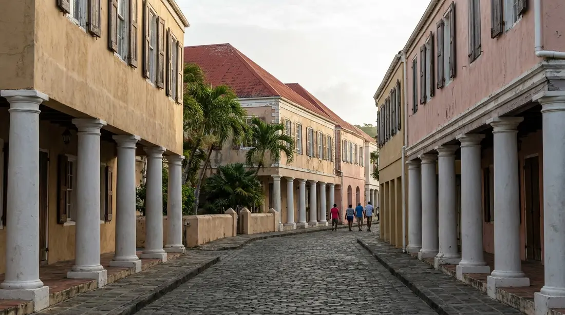
Arcaded sidewalks, yellow ballast brick, pastel stone, red roofs: a walking look at one of the world's few African-Danish towns.
St. Croix keeps two complete Danish colonial towns, and both can be read like documents once you know the vocabulary. Scholars class Christiansted with a tiny group of towns anywhere on earth that can properly be called African-Danish: planned on Danish drawing boards, raised by enslaved African builders and craftsmen, and still standing in pastel-plastered stone under red roofs, on streets that meet the harbor at right angles. Frederiksted answers it with sawn Victorian woodwork riding on Danish masonry. This page is the field guide: each building element and the job it did, the styles in order, a walking route through each town using buildings you can see from public streets, and the preservation record. The five Park Service buildings and the two forts have their own pages; here they get one line each, because this page is about how to read everything else.
Two towns, one rulebook
The reason both towns look composed rather than accidental is that almost nothing about their appearance was left to choice. Frederik Moth staked out Strandgade, the shore street of Christiansted, in May 1735, and the rest of the grid followed over the next decade. Company Street was drawn as the principal axis, running straight at the entrance of the fort on one end and stopping at the town burial ground on the other. In 1747 the Danish administration imposed a building code on the colony's towns, and its provisions did most of the design work you now photograph. Per the National Register inventory of the district, the code required new buildings to stand in a straight line along the building line at the sidewalk; construction had to be masonry, or wood carried on masonry footings, with shingle roofs that a later revision changed to tile; and thatch was banned from town except in the waterfront and western blocks assigned to the poorest residents. A 1749 act pushed all burials to the public cemetery at the western edge and the yards of three approved churches. The result was a town of solid block-long building rows at the sidewalk, in fireproof materials, with regulated roofs, three centuries before anyone used the words design review.
Frederiksted got the identical code and a fresh grid. The surveyor Jens M. Beck drew it in 1751 as two matching sections of blocks with the new fort as the hinge between them; the northern half was never built, the town grew southward instead with block tiers added in 1767 and 1875, and every street was platted at a generous forty or fifty feet of width. One more decision shaped the west end permanently: the government kept ownership of the seaward side of Strandgade and allowed nothing on it except wharves and small sheds. That is why Frederiksted, alone among the old Danish West Indian ports, still faces open water down its whole length instead of a wall of warehouses. The town histories live in the Christiansted guide and the Frederiksted guide; what follows is the architecture itself.

Walls
Start with what the buildings are made of, because every other element sits on it. The standard wall of both towns is rubble masonry: irregular local stone bedded in lime mortar, often around two feet thick. The mass was the point. A two-foot rubble wall soaks up the day's heat and releases it slowly, keeps interiors dim and cool behind deliberately modest window openings, and shrugs off wind that strips lighter construction. When you see a plastered wall with a chunk of render missing, look into the scar; the jumble of fieldstone, brick bats and coral inside is the true structure of both towns.
Brick came in two forms. The famous one is the hard yellow Flensburg-type brick shipped out from Denmark in the holds of vessels that would have crossed the Atlantic empty otherwise; the bricks served as ballast on the outbound run and building stock on arrival, and they went into Fort Christiansvaern and a large share of the walls, arches and trim in both towns. Look for them lining door and window openings and forming quoins at the corners of rubble buildings, where a crisp, regular material was needed at the edges of an irregular one. Red brick appears too, and after 1878 much of Frederiksted's commercial rebuilding was brick outright.
The third material is the strangest to modern eyes: coral. Blocks of reef limestone, called coral stone or limestone marl in the survey records, cut easily when fresh and hardened in the air, so builders shaped it into moldings, quoins, cornices, columns and whole ground-floor walls. Several Frederiksted buildings still show their coral block courses without any plaster coat, including the tower of St. Paul's, and the porous, pitted surface reads unmistakably once you have seen it once. Lime for the mortar and plaster was burned locally, and the mix was often stretched with crushed brick and seashell, which helped the walls shed the moisture they absorbed. The same material set built the plantation great houses and mills inland; Estate Whim and the sugar mill ruins show it outside town.
Lime plaster and the colors
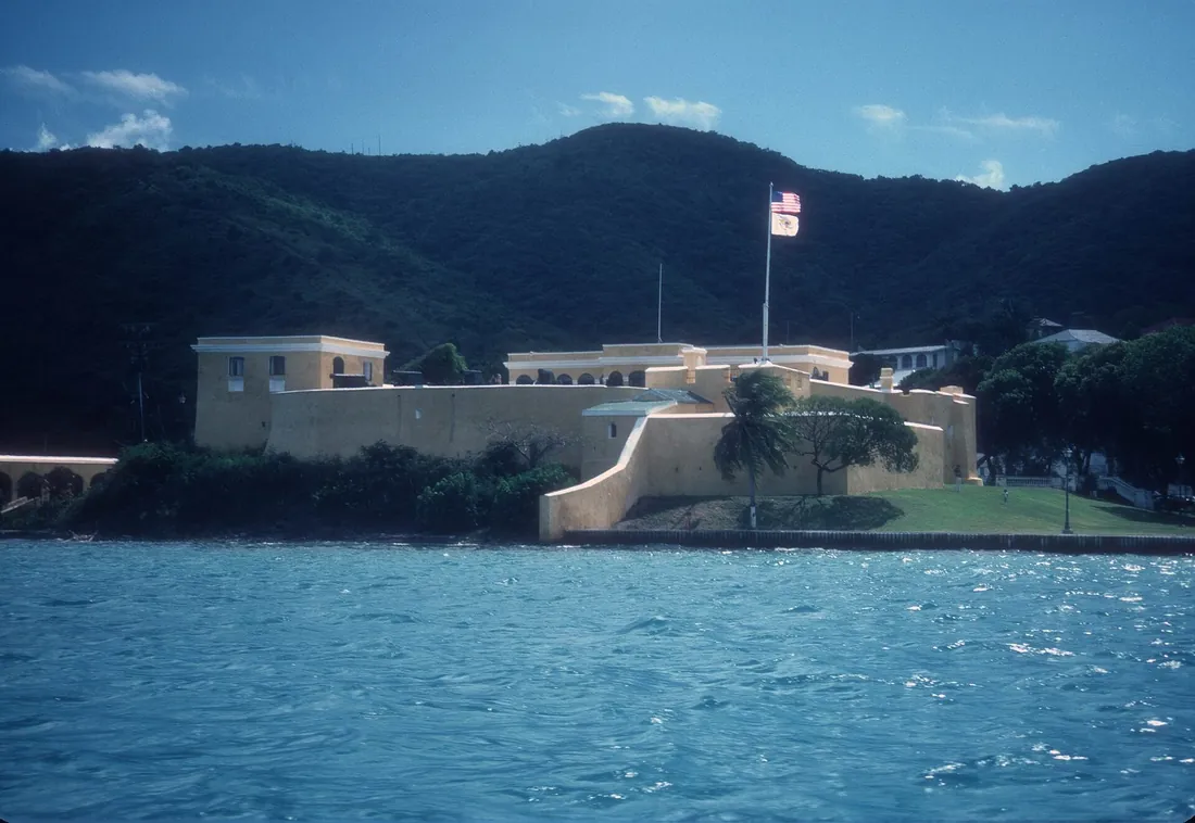
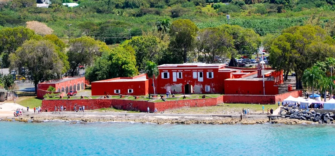
Nearly every masonry wall in both towns wears a coat of lime plaster, and the plaster wears color. The traditional range, as the island's architectural writers record it, ran to yellow ochre, cream and white, with red appearing on trim and on a handful of whole buildings, and pinks, pale greens and blues joining the palette over time; treat any very precise claim about the original shade of a given building with suspicion, because lime wash was renewed constantly and colors shifted with each owner and era. The scheme had a job beyond looks. Light colors throw back the sun and keep the wall mass cooler, and the strong ochre of official buildings announced the Danish state; the two forts are the color key to everything else, the yellow of Christiansvaern and the deep red of Frederik. What you should notice on the walk is the texture: lime wash sits soft and slightly cloudy on the plaster, quite unlike modern acrylic paint, and buildings restored with the right materials glow in low sun in a way the vinyl-painted ones cannot.
Arcades and galleries
The signature element of Crucian streets carries two names, and using them precisely helps you see. An arcade is the row of masonry arches at ground level, carrying the building's upper floor out over the public sidewalk so that pedestrians pass through a shaded tunnel of arches. A gallery, in the usage of the old surveys, is the covered upper porch itself, projecting to the street line above the walk; islanders also use the word loosely for the whole covered sidewalk. The National Register inventory records that the arcades grew from a long tradition of property owners building out over the public walk rather than from any single ordinance, and that is why no two blocks match: one owner sprang his arches in yellow brick, the next in coral, the next carried his gallery on plain timber posts, and the rhythm of King and Company Streets is the sum of a hundred private decisions inside one shared habit.
The job was climate. The covered walks put the whole commercial district in shade and keep rain off the shopper, the shopfront and the merchandise at once; the projecting gallery shades the wall below it and gives the upper floor a cool outdoor room that catches the trade wind. Christiansted's finest continuous runs are on King and Company Streets, and the walk from the fort up King Street remains the best single introduction. Frederiksted's version reads lighter, with more timber posts and sawn wood detail, much of it from the rebuilding after 1878. Where you see the arcade principle continued in an unmistakably twentieth-century commercial building, that is deliberate too; the newer construction in both districts was expected to keep the covered walk going.
Roofs built for storms
Look up and the skyline of both towns repeats one shape: the hip roof, pitched on all four sides with no vertical gable end. The 1976 survey called the high hipped roof the traditional West Indian form and noted that virtually every older building in the Christiansted core carries one, with the gable-roofed churches as the standing exception. The logic is hurricane aerodynamics, proven by two centuries of trial. A gable end is a flat sail that wind can pry at; a hipped roof presents a low, braced slope in every direction, and its four-sided frame ties the structure together. You will spot variants: jerkin-head roofs that clip the gable into a small hip, like the one on Benjamin House in Frederiksted; steep early pitches beside the shallower hips of later rebuilds; and, since the storms of the last generation, a great deal of modern galvanized metal doing the work shingles and tile once did. Red remains the traditional roof color of Christiansted's skyline, best seen from the fort's gun deck.
Shutters, jalousies and window logic
Glass was scarce, expensive and pointless in this climate, so the traditional window is an opening with layers of wood instead of panes. Solid board shutters, the hurricane shutters, close the wall completely against storm and sun; many older windows in the districts were recorded by the surveys as shuttered with no glazing at all. Jalousies, the angled wooden louvers, are the refinement: they admit moving air and striped light while blocking rain, glare and the view in. On finer houses the sashes and louvers combine, and full-length window openings reach the floor so the rooms breathe onto the galleries. Count the layers on one good facade and you can read the whole system: masonry mass to slow the heat, small or shaded openings to control it, louvers to move the air, solid shutters as armor, and the whole set operable by season, hour and weather. It is passive climate control at a sophistication level modern builders are only now circling back to.
Ground floors, upper floors and stairs
The classic town building of both districts is a duplex of functions stacked vertically. The ground floor is masonry, thick-walled, at or near sidewalk level, and was built for commerce or storage; the upper floor holds the dwelling, reached by an internal stair or by a stairway in a rear courtyard, and is quite often wood frame riding on the masonry base. The survey records this masonry-below, frame-above combination throughout both towns, with the frame stories shingled on the earlier buildings and clapboarded on the later. The logic runs three ways at once: the masonry story resists flood, cart traffic and fire; the frame story flexes in wind and is cooler to sleep in; and when a hurricane or a fire takes the wood, the stone survives to carry a new top, which is exactly the story Frederiksted tells block after block. On the hillier southern streets of Christiansted, houses also stand on raised basements and terraced foundations, with living floors lifted a half story or more above the street.
That lift produced the islands' most charming architectural term. A welcoming-arms staircase is a double exterior stair whose two curved flights sweep down and outward from a shared landing, so the plan spreads like open arms. The name is standard across the former Danish islands, and it is no tourist coinage; the Christiansted National Register inventory itself uses it for the double curved stairway at 67 East Street, which lands on a drum-shaped stone platform. The grandest stairs in the towns are cousins of the form rather than textbook examples, including the monumental exterior stair added to Government House in 1830 and the buttressed flight climbing the front of the Christiansted custom house, and the plantation great houses of the countryside kept the purest versions. Behind the street facades, look for one more habit of the type: interior courtyards, walled, often with a separate cookhouse so that the heat and fire risk of the kitchen stayed out of the main structure.
The styles in order
Four broad layers account for nearly everything you will see, and dating a building by eye becomes easy once you hold the sequence.
- Danish colonial, mid to late 1700s. The founding fabric: rubble and brick masonry, arcades, hip roofs, restrained baroque decoration on the most ambitious work. The three-story center section of Government House, built 1747 as a merchant's residence, is the showpiece of the period.
- Neoclassical, roughly 1790s to 1840s. Belt courses, engaged pilasters, keystones, molded cornices and parapets applied with increasing polish; the era of the towns' most elegant civic fronts, including the 1830s completion of the Christiansted custom house and the 1834 church tower on King Street. The Steeple Building's tower of 1793 to 1796 belongs here as well.
- Gothic Revival, 1840s onward, in the churches. Pointed arches, buttresses, crenellated towers and pinnacles, executed in local coral limestone and brick: the Anglican church in Christiansted of 1849 and, in Frederiksted, St. Patrick's of 1848 and the circa-1848 tower of St. Paul's.
- Victorian, after October 1878. The Fireburn labor revolt burned the four blocks of Frederiksted's business district; the losses were put at $106,300, and among the grievances behind the uprising was a legal maximum wage of ten cents a day. The district rebuilt fast, in the ornament of its own decade, and gingerbread went up on Danish bones: sawn balusters, latticework porches, pierced bargeboards and turned posts, much of it standing on masonry ground floors and foundations that predate the fire. The history of the revolt is in the Fireburn guide; the streetscape it produced is below.
The layers rarely sit apart. A single Frederiksted facade can carry a 1750s coral wall, an 1820s belt course and an 1880s gallery, and reading the stack is the pleasure of the walk. For how the island accumulated this many eras of ownership in the first place, see the seven flags of St. Croix.
Danish street names decoded
The street grid still answers to its Danish names, and most corners in both towns post the old form beside the English. A short glossary turns the signs into plain speech; "gade" is street, and "tvaergade" a cross street.
| Danish name | English name | Meaning |
|---|---|---|
| Strandgade | Strand Street | Shore or beach street; the waterfront street in both towns |
| Kongensgade | King Street | The king's street |
| Dronningensgade | Queen Street | The queen's street |
| Kongens Tvaergade | King Cross Street | The king's cross street |
| Dronningens Tvaergade | Queen Cross Street | The queen's cross street |
| Torvegade | Market Street (Frederiksted) | Market street, from "torv," a market square |
| Ostergade | East Street (Christiansted) | Eastern street |
| Bjergegade | Hill Street | Mountain or hill street |
| Fisketorvet / Fisher Street area | Fisher Street (Frederiksted) | The fish market end of town |
Company Street in Christiansted is the outlier with an English word at its heart: it recalls the chartered Danish West India & Guinea Company, whose warehouse still stands a block off it. Royal names went to the long streets, working names to the short ones, and the pattern repeats in Charlotte Amalie on St. Thomas, which shared the same colonial administration until the seat moved there in 1871.
A Christiansted walk
The route below runs a little over a mile at a stroll and needs sixty to ninety minutes without interiors. Every stop is visible from a public street or from the free-to-walk park grounds. Start at the waterfront park, where the five National Park Service buildings stand; each has one line here because the historic site guide and the fort's own page carry their full stories.
- Fort Christiansvaern. Begun 1738 and defensible by 1740: the island's masterclass in yellow ballast brick, and the color reference for the whole town.
- The Scale House, with the Custom House beside it. The 1856 scale building and, beside it, the customs building whose oldest first-floor fabric dates to 1751-52; climb nothing, just study the custom house's buttressed exterior stair and arcaded base as the town's finest neoclassical front.
- The old company warehouse. Finished in 1749 for the West India & Guinea trade; note the sheer plainness of a working company depot beside the dressed-up civic fronts.
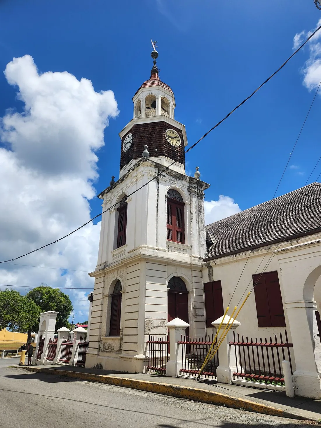
- The Steeple Building. Built 1750-53 as the Lutheran church, with the Georgian steeple added 1793-96; its tower is the town's vertical landmark.
- Government House, King Street. The long three-story block reads as one building and is actually three campaigns: a baroque merchant's house of 1747 at the center, wings of about 1800, and a separate 1794-97 residence on Queen Cross Street joined to the rest in 1830, when the monumental staircase went on. Stand across King Street and find the seams; then read the arcaded ground floor, the heavy belt courses and the engaged pilasters as the neoclassical dress uniform of Danish government.
- Lutheran Church of Lord God of Sabaoth, 1120 King Street. Often cited as the oldest church building on St. Croix, built before 1740 for a Dutch Reformed congregation; the Lutherans moved in during 1831-34 after hurricanes wrecked their Steeple Building successor quarters, adding the three-tier tower attributed to Albert Lovmand, architect to the Danish colonies. Walk both long sides: the curved Dutch-style parapet gables are unique in town, the rubble walls show brick linings at every opening, and the bell inside was cast in Copenhagen in 1793.
- The Lutheran parsonage, 51 King Street. A textbook merchant-scale town house: five-arch arcade with keystones, gallery above, dentil cornice, and a doorway framed by Tuscan columns under a small triangular pediment.
- 45 King Street. A three-story U-plan residence around an inner courtyard, long run as a guest house; the trick to catch is the stucco scored in neat lines to imitate dressed stone blocks, thrift dressed as grandeur.
- 56 Company Street. A two-story U-shaped house whose segmental-arched arcade is among the best in town; the walled courtyard behind kept a separate cookhouse.
- Holy Cross Catholic Church, Company Street. The oldest Catholic parish in the Virgin Islands, first built 1755 and heavily reworked in the 1850s; the plan is a cross, a nod to the island's own name, and the facade mixes classical bones with neo-Gothic pointed arches and pinnacles.
- 17 Church Street. A three-story town house of unusual scale, its face divided by eight full-height pilasters over a low ground-floor arcade; stand back to see how the upper galleries push to the curb line in the town's characteristic way.
- The hill streets. Finish with the short climb up East Street or Hill Street, where the town turns residential and wooden. At 67 East Street stands the double curved welcoming-arms stair on its round stone platform, named exactly that in the federal survey; at 4-5 Hill Street a gallery plays three different arch sizes across five bays; at 56-58 Hill Street one of the island's finest town houses runs six arched bays over a full basement. These are private properties on public streets; look from the sidewalk. Up here the grand masonry gives way to one-story hip-roofed cottages in shingle and clapboard, the vernacular end of the same tradition, and the 1976 survey read this split between the masonry core and the frame hills as the built record of the town's colonial class lines, over a thousand free Black residents having made the western and southern quarters their own by 1800.
On the way back down, cross the mid-block widening of Company Street between the two cross streets: that space was the Sunday Market, where enslaved and free people traded on their one day off, and the block-long opening between Company and King at the west end was the planned Market Square. The town's other threads, the boardwalk, the shops, the young clerk from Nevis, live in the boardwalk guide, the hook bracelet story and the Hamilton page, and the 1820 pharmacy interior at Apothecary Hall is the best-preserved Danish-era commercial interior you can enter.
Christiansted stops at a glance
| Stop | Date | What to notice |
|---|---|---|
| Fort Christiansvaern | 1738-1749 | Yellow ballast brick; the model for the town's color |
| Danish Custom House | 1751-52 core, finished 1840s | Buttressed outdoor stair; arcade with keystones; parapet |
| Steeple Building | 1750-53; tower 1793-96 | Georgian steeple on a plain masonry church box |
| Government House | 1747, joined 1830 | Three buildings seamed into one; pilasters and belt courses |
| Lutheran church, King St. | Before 1740; tower 1831-34 | Curved Dutch-style gables; brick-lined openings in rubble |
| 51 King Street | Danish era | Tuscan-columned doorway; five keystoned arches |
| 45 King Street | Danish era | Stucco scored to imitate cut stone; U-plan courtyard |
| 56 Company Street | Danish era | Segmental-arched arcade; courtyard cookhouse behind |
| Holy Cross Church | 1755, altered 1850s | Cross-shaped plan; Gothic points on classical bones |
| 17 Church Street | 18th century | Eight full-height pilasters; galleries out to the curb |
| 67 East Street | 18th-19th century | Welcoming-arms double stair on a drum-shaped platform |
| Hill Street houses | 18th-19th century | Frame cottages; galleries with mismatched arches |
A Frederiksted walk
The west end's version is shorter, flatter and differently instructive: forty-five minutes to an hour, best in the low light before a sunset. What you are reading here is a masonry Danish town wearing a Victorian wardrobe, and the game on every block is to find the 1878 fire line on the facade, the level where old stone stops and post-fire wood begins.
- Fort Frederik. The deep-red fort of 1752-1760 anchors the north end; its museum, ramparts and the emancipation history of July 3, 1848 are covered in the Fort Frederik guide, so give the exterior one long look, the rubble curtains and later clock tower, and walk on.
- The Frederiksted Customs House, Custom House Street. The federal building survey ranks it a fine example of late-1700s Danish civic work, and it doubles as a lesson in alteration: the second-story frame gallery and the hip roof rising above the original parapet were added later, softening a once-severe classical block. Find the three arched bays at the center, the quoined corners and the sawn scrollwork on the gallery's eaves board.
- Victoria House, 7-8 Strand Street. The most elaborately detailed building in the Virgin Islands by the 1976 survey's estimate, and the town's Victorian trophy. An Irish merchant, Edward Masterson, raised it in 1881 on the remains of an eighteenth-century house lost in the Fireburn; the masonry ground story with its offset stair survives below two levels of woodwork, including trefoil latticework in the porch arches and an inset third story ringed by an open porch. One building, whole timeline.
- Strand and King Street arcades. Between stops, read the rows: post-fire brick commercial buildings carrying their arcades on flat segmental arches, second-story galleries on slim timber posts, sawn balusters and pierced bargeboards everywhere. The big two-story corner building where Custom House Street meets King Street is a type specimen of the rebuilt business district.
- The corner of King Cross and Queen Streets. The old shop-and-residence on the southwest corner is the early-1800s combination building at its best: a two-story arcade and gallery wrapping both street fronts on tall timber posts with decorative sawn brackets, unplastered coral limestone walls below, clapboard above, and a freestanding masonry stair climbing the outside.
- Benjamin House, 48 Queen Street. Early-1800s Danish domestic design in one package: brick over a rubble foundation, a six-arch arcade across the front, lime-washed upper walls, jalousied windows, a wrought-iron balcony across the middle bays, and dormers in a jerkin-head roof, the clipped-gable form worth learning here.
- Market Square, Queen Street at Market Street. Platted in Beck's 1751 plan at the crossing of Torvegade and Dronningensgade, the square never grew into the civic heart intended; a twentieth-century open market shed occupies one corner, and the frame of buildings around the space went up after the 1878 fire. It is the walk's most instructive stop, a plan that history declined to fill in.
- St. Patrick's Catholic Church, Prince Street. Built 1848 of coral limestone with brick-lined openings: Gothic Revival pointed arches under curved gable profiles that the survey compared to Spanish Mission churches, with the tall brick bell tower added later and a walled churchyard whose cemetery holds a monument to sailors lost in the 1867 tsunami.
- St. Paul's Anglican Church, Prince Street. The main body dates to about 1810-1812, a hip-roofed hall with pointed-arch windows running to the floor; the three-story English Gothic tower of about 1848 became the main entrance, and it is the best place in either town to study raw coral limestone block, left unplastered, with yellow Danish brick lining the pointed arches and crenellations and corner pinnacles up top.
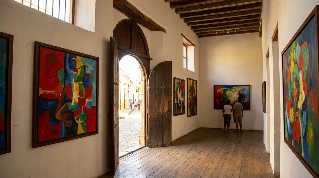
End at the waterfront. The free art museum in an eighteenth-century Strand Street building is worth the stop when open, covered in the museum guide, and the pier and beaches fill the rest of a west-end day.
The preservation record
Both towns are protected on paper twice over. The Christiansted Historic District, 135.9 acres taking in the whole colonial town, the Park Service site and a locally administered architectural control district, entered the National Register of Historic Places on July 30, 1976; the Frederiksted Historic District, 101 acres matching the old town's legal boundaries, followed that August. Select buildings in both had already been measured and photographed for the Historic American Buildings Survey, whose records sit in the Library of Congress, and those 1976 nomination forms remain the best free architectural tour texts ever written about the island.
Paper protection has been the easy part. Hurricane Hugo crossed St. Croix directly on September 17, 1989 with gusts measured to 168 mph and damaged some ninety percent of the island's buildings; frame upper stories and galleries suffered worst, exactly the elements this page teaches, and the 2017 storm season brought more losses. The current state: both districts are working towns, with beautifully restored blocks standing next to weathered ones and a scattering of vacant shells and bare masonry ruins, more of them in Frederiksted than Christiansted. That mix is worth seeing clearly rather than around. The masonry endures, the woodwork comes and goes, repairs proceed building by building as money allows, and the towns remain lived-in rather than curated, which is a large part of why they still feel real. Denmark's flag left on Transfer Day in 1917; the building tradition never did.
Photography manners
Most of what this page describes is someone's home, shop or church, so a few habits keep the walk welcome. Shoot freely from public sidewalks and streets; that is where every stop above was chosen to be seen from. Skip gateways, courtyards and gallery stairs on private property, and treat open doors and upper-floor windows as private even when the architecture around them is spectacular. Ask before photographing people, vendors and children, and expect a yes more often than a no. The churches are active congregations, so stay outside during services and follow posted rules inside. Government House is a working territorial government building; photograph the exterior at will and follow staff instructions on days the gates stand open. Morning light favors Christiansted's yellows, late afternoon favors Frederiksted's reds and the west-facing Strand, and the arcades themselves photograph best looking down their length, arch through arch.
Questions guests ask
What is the difference between an arcade and a gallery?
In the language of the historic surveys, the arcade is the ground-level row of masonry arches over the sidewalk, and the gallery is the covered upper porch projecting above it; in everyday island speech, gallery covers the whole covered-walk arrangement, and nobody will correct you either way. The distinction is useful because the two parts have different jobs: the arcade shelters the public walk and the shopfronts, while the gallery is private outdoor living space that also shades the wall below. Many buildings carry one without the other, which is part of what gives each block its own rhythm.
How long do the two walks take?
Budget sixty to ninety minutes for the Christiansted route and forty-five minutes to an hour for Frederiksted, both at an easy pace with photo stops and neither entering any building. Interiors add time where they are open: about an hour for the fort, ten minutes for Apothecary Hall, and whatever a church visit invites. The towns sit about forty minutes apart by road, so pairing both walks in one day is realistic and the comparison teaches more than either town alone. The classic split is Christiansted in the morning for the light on the yellow masonry and Frederiksted before sunset.
Can you go inside any of the buildings on the walks?
Some. Fort Christiansvaern admits visitors daily for $10 at last check, the churches generally open outside service times at the congregation's discretion, Apothecary Hall keeps limited museum days, and Fort Frederik and the Frederiksted art museum have posted hours covered on their own pages. Government House opens as official schedules allow. Nearly everything else is a private residence or business, and the walks are designed so that nothing requires entry; the architecture argues its case from the sidewalk.
What is a welcoming-arms staircase?
A double exterior stair whose two curved flights descend outward from one landing, spreading like open arms toward an arriving guest. The term is the standard one across the former Danish West Indies, and the federal survey of Christiansted applies it by name to the stair at 67 East Street. The purest examples belong to the plantation great houses, where the stair carried visitors up past the storage ground floor to the main living level; in the towns you will more often meet its relatives, grand single flights like the one on Government House and the buttressed customs stair on the wharf.
Why does Frederiksted look Victorian when it is a Danish town?
Because its business district burned in the Fireburn labor revolt of October 1878 and was rebuilt immediately in the ornamental fashion of that decade. The fire took the wooden upper works and spared much of the masonry, so the town raised sawn-wood balconies, latticework and bargeboards on ground floors and foundations the Danes had built more than a century earlier. Look at almost any commercial block and you can trace the seam where stone gives way to wood. The plan underneath, streets, lots and building lines, is still the 1751 Danish survey.
Are the Danish street names official?
The English names are the working ones, and the Danish forms survive on signs, maps and deeds; many corners in both towns post both. The names translate directly, King Street from Kongensgade, Queen Street from Dronningensgade, Strand from Strandgade, the shore street, and Frederiksted's Market Street from Torvegade. Addresses still follow the old Danish lot-numbering rather than modern sequential numbers, which is why a short street can carry four-digit addresses like 1120 King Street. Locals navigate by landmarks more than numbers, and after a day on foot you will too.
Which single block shows the most in the least time?
In Christiansted, King Street between Government House and the Lutheran church: government neoclassicism, an arcaded merchant row, a pre-1740 church with Dutch gables and the fort's yellow mass at the bottom of the hill, all inside three hundred yards. In Frederiksted, Strand Street from the customs house past Victoria House: Danish civic masonry, post-fire Victorian showpieces and the open sea where every other colonial port built warehouses, because the Danish crown kept that side of the street empty.
Villas near the walks
Most of our guests do the Christiansted walk as part of an ordinary town morning, since most of our twelve homes sit on the Christiansted side of the island within an easy drive of King Street; Shoy's Beach House is about five minutes out, and The Cerulean with the wider East End collection, puts the old town fifteen to twenty minutes away with a swim waiting afterward. For the Frederiksted walk, Sunset Sea-Clusion makes the west end a neighborhood stroll and the sunset the walk's last stop. Driving is on the left and parking for both towns lives on the getting-around reference; the villas index has every home.
Sources
Written from official and first-party sources, checked August 2026. Hours, prices and event dates change — confirm before you go.
In this guide
Stay nearby
On The Shoys beach: six bedrooms, six baths, pool and hot tub, room for twelve, and the beach through the back garden.
 Shoy's Beach House6 bd · 6 ba · sleeps 12 · Christiansted
More in History & Culture
Sources
12 references, listed in full at the end of this guide — official park, refuge, tourism-board and business sources, checked August 2026.